The New Cultivate LA Map is Live!
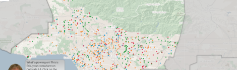
Check out the new and improved Cultivate LA interactive map! Our data is completely updated, and there are over 1,000 urban agriculture sites represented on the map. We’ve also revamped our website, […]
Check out the new and improved Cultivate LA interactive map! Our data is completely updated, and there are over 1,000 urban agriculture sites represented on the map. We’ve also revamped our website, […]
We’re updating our data! If you know of any urban agriculture sites that have been active in the past year, please fill out this survey and let us know. Feel free to […]
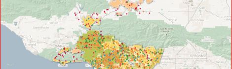
Click above for our Interactive Map*! Let us know if we missed an agricultural site! *Requires Google Chrome, Safari 6.0.4 or higher

Full Report: Cultivate L.A. – An Assessment of Urban Agriculture in Los Angeles County Cultivate L.A. Executive Summary + Chapter Highlights Cultivate L.A. – Summary of Urban Agriculture Regulations in […]

What is the current regulatory landscape for urban agriculture in Los Angeles County? The landscape of agricultural regulation is rocky, confusing, and often illogical. Los Angeles County residents—from backyard gardeners […]

How many urban agriculture sites are there in Los Angeles County? Where are they located? In LA County, various organizations map and list the occurrences of specific agricultural activities in […]

What are the benefits and challenges of implementing school garden programs? School gardens may seem like a recent addition to most school landscapes but they have existed for more than […]

How does urban agriculture fit into the greater economy of Los Angeles? To understand the economic potential of the urban agriculture industry, this section’s research utilized theories of the New […]

How do urban growers distribute their products? Just like any industry, urban agriculture requires a distribution system. Technological advances in food transportation and processing have enabled distributors to move food […]
